|
The Newtown Connections packages are good but they could be a lot better The next stage of Wellington City Council's Newtown Connections project is now underway. Newtown Connections is part of a programme to develop a connected citywide cycle network so people of all ages and abilities can safely choose to make more trips by bike. The council is asking for feedback on three different packages of routes and possible street changes in Newtown, Berhampore and Mt Cook by Tuesday 11 December. You can read the council's media release here. The Dominion Post also produced a reasonably balanced overview of what's happening despite the slightly reductive headline: Options revealed to connect Wellington's Island Bay cycleway to Basin Reserve. Conditions for people on bikes in Newtown and Berhampore are far from ideal The current stage is the second of three opportunities the community will have to help shape what happens in the wider Newtown area. More than 770 people provided their initial thoughts a few months ago during the first round of community discussion. Eighty-five percent said it was important or very important to make it easier and safer for more people to ride bikes in and around the Newtown area. All the information collected is summarised in the Community Engagement Feedback Analysis Report, which also provides a good overview of the extensive engagement that occurred. The feedback was then used to create a Community Brief that summarises the community's wishes. The planners used the Community Brief to develop the packages of possible street changes that are now being consulted on. There's more information on how the packages were developed here. It's important to note that the packages are not discrete options and the consultation is not a vote. The council simply wants to hear what you think at this stage. As Mayor Justin Lester says “Nothing is at a detailed design stage yet, and no decisions on routes or changes have been made – so it is a very good time to get involved. The more community input we can get at this stage, the better.” Councillor Sarah Free says "we want people to look at the routes up for discussion, what’s possible, what’s likely to provide the greatest benefits, and what these connections would mean for various streets. The plan that’s developed could well be a mix of the different packages". I have to say I think Wellington City Council have done a great job putting all this together. It's by far the most comprehensive consultation on this type of project they've done so far. There's a lot of information to look at but the website is nicely done and easy to understand. You can look at an overview of the packages and then go through each one section by section. There's also a very comprehensive summary of the parking impacts of each package. Here's the three packages side by side (click image to enlarge): 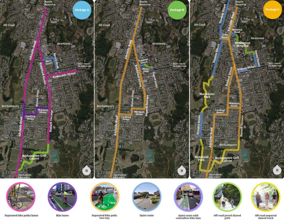 Here's animated gifs of each package that give a better idea of what the treatments will be in different areas. Don't forget that if you go to the Newtown Connections website and click through the detail of each package you can see what the proposed treatment for every section of each package is. Package A: 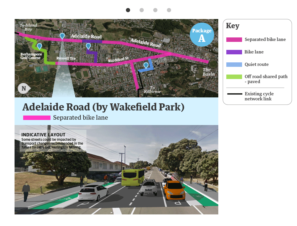 Package B: 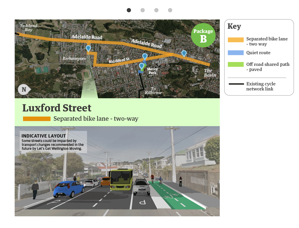 Package C: 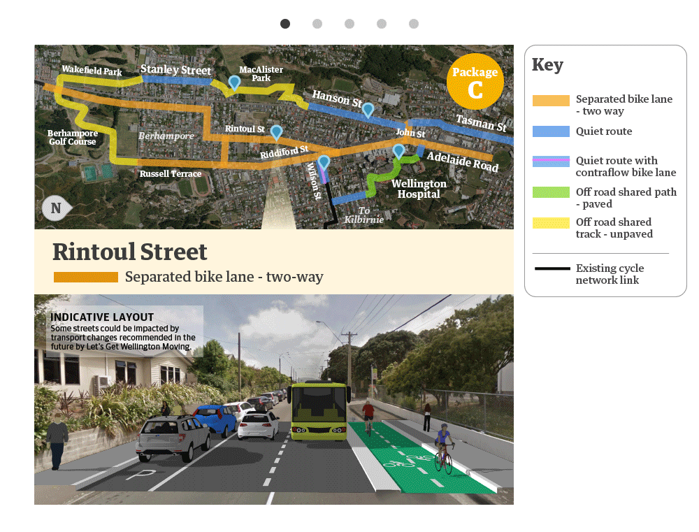 The good news is that all the packages will be a vast improvement on what's there now, which is basically nothing. Every package gives someone on a bike the ability to cycle from Island Bay to Newtown and on to the Basin Reserve entirely separated from motor vehicles. However, a bit of a problem in my mind is that two of the packages (B & C) rely very heavily on 2-way separated bike lanes. 2-way bike lanes are OK but they're really not ideal. Some cycling advocates think bi-directional bike lanes are a folly while others take a more pragmatic view that they can sometimes be justified. The main reason they appear to be used so much in these packages is to save space, and on-street parking. In principle, I think the default treatment in an urban environment should be to use 1-way separated bike lanes on both sides of the road wherever possible. What "wherever possible" means, and how that impacts parking, is going to be at the heart of the debate. It also seems to me that the designers have tried to use one consistent treatment within a package as much as possible. This is presumably to minimise the transitions from one kind of cycleway to another i.e. from 1-way to 2-way and vice versa. I don't think we should be too concerned about transitions between different types of cycleway. Mainly because we're not going to be able to avoid this in Wellington unless 2-way cycleways become the norm, which would be dumb & significantly lower the overall level of service of the network. Transitions can be managed as long as they are well-designed. For example, anywhere where there is a set of traffic lights it should be relatively simple to design a transition from one type of cycleway to another. So, on balance, I am leaning towards Package C as being the one worth developing further. It has the best overall connectivity and greatest number of options (both routes and types of cycleway) for people on bikes to choose to get around. Package A looks good too, but does have a big impact on parking. It's also not quite as connected as Package C and I think I agree that putting cycleways on some of the steep gradients along Adelaide Rd would not be the kind of 'all ages & abilities' infrastructure that the Community Brief demands. How well each package meets the objectives set by the community in the Community Brief is a really fundamental question. Wellington City Council have done their own analysis of that and I think they've got it about right, with Package C just edging out Package A. What do you think? 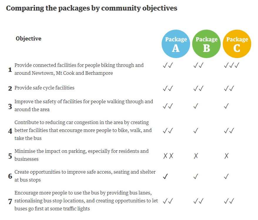 However, although I like Package C I think it is far too reliant on 2-way cycleways. I'd like to propose a Package C+, in which the entire stretch from the Basin Reserve, along Adelaide Rd (to John St) and Riddiford St (to Russell Tce, maybe as far as Waripori St) becomes 1-way separated lanes. Package C+ would look a bit like this. The pink is 1-way separated bike lanes on both sides. The orange is 2-way lanes. Yellow and green are off-road paths. Blue is quiet streets. 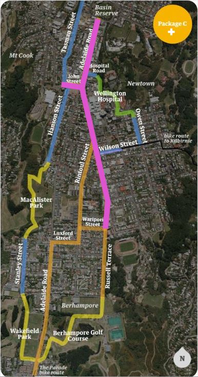 The key to this is that Package C+ can be done with no additional impact on parking (if I'm reading the detail of Package A correctly, where this is already the treatment along that stretch). If so, why on earth wouldn't we do it? In fact, it's the absolute minimum we should do. Once you've done that it really does beg the question whether you go further & put in more 1-way cycleways (potentially joining up with the Island Bay Cycleway) even though it will then start to impact on parking. The focus of that discussion would be firmly on Waripori St and Luxford St to get across to Adelaide Road before carrying on from the Berhampore Shops to Dee St. By my rough calcs the minimum parking lost under each package as presented is: A: approximately 540 reduction in on-street parking B: approximately 140 reduction in on-street parking C (and C+): approximately 230 reduction in on-street parking If we extended C+ along Waripori, Luxford & along Adelaide Rd from the Berhampore shops to Dee St I think that would add approximately 120 parks lost to Package C (approximately 350 lost in total). We could, and should, also have a discussion about Rintoul St. Will this be the moment that Wellington City Council finally steps up and says unequivocally that mobility and safety are a higher priority than on-street parking? If so, Rintoul Street provides a more direct route to connect possible 1-way lanes in Newtown to the 1-way lanes we already have in Island Bay. However, this would result in a reduction in on-street parking on Rintoul Street of an extra 75 parks (over what is already proposed as part of Package C) and would likely push the total reduction in parking in Package C towards 400. What do you think? Whatever it is, make sure you go the Newtown Connections website and have your say! Regan
0 Comments
Your comment will be posted after it is approved.
Leave a Reply. |
Archives
October 2022
|
 RSS Feed